New 3D Radar at Puig de Randa – Progress with Open Questions
New 3D Radar at Puig de Randa – Progress with Open Questions
A new primary radar on Puig de Randa is intended to better monitor the airspace over the Balearic Islands. What the technology can do, who pays for it — and which questions remain open.
New 3D Radar at Puig de Randa – Progress with Open Questions
Key question: Does the installation really make the airspace safer — and what does it mean for transparency, the environment and local residents?
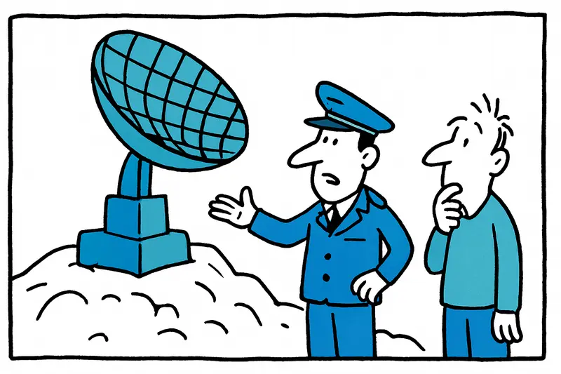
On the summit of Puig de Randa, where the bells of the Santuario Nostra Senyora de Cura ring down to the village and every now and then a scooter winds up the narrow switchback road, a new radar station on Puig de Randa has been put into operation. The operator is Enaire; according to official information the system is intended to detect aircraft over the Balearics more precisely and has a range of about 220 kilometers. Technically, the system processes data in real time and, according to the project concept, is more robust against interference sources such as wind farms or echo effects. Financial basis: funds from European sources.
That sounds like clear advantages: better detection, faster response in emergencies. But the sober assessment alone does not answer everything. Viewed critically, at least three questions remain open: Who guarantees that the new data sources remain reliable in the long term? How transparent are the decision-making processes for site selection, operation and fault remediation? And what consequences does the installation have for local habitats, sightlines and recreational areas around the mountain?
On the technical side: primary radars provide positional data without relying on transponders. That is essential for monitoring uncooperative aircraft. At the same time, primary radars are sensitive to reflections, for example from large wind turbines, and to electronic interference. That the system 'calculates in real time' and is supposed to reduce interference is an improvement. What remains unclear, however, is which test series were carried out before commissioning, how often software updates are needed and how outages are compensated — in other words, the redundancy in the network.
What is missing in the public discourse: first, concrete figures on downtime and planned maintenance windows; second, a comprehensible presentation of how the installation cooperates with existing radar systems in the Balearics; third, information on the environmental assessment, specifically regarding electromagnetic exposure and possible impacts on birds and the local neighborhood. Practically speaking, I miss a clear contact point for citizen questions: who answers local concerns when unusual lights appear at night or installation work brings extra traffic?
An everyday scene from Randa: Saturday afternoon, the bakery on the village square fills up, tourists photograph the view over the island interior, and on the Puig technicians work on measurement setups. Conversation: 'The radar station brings safety,' says the restaurant owner, 'but it's good to know how often someone up there checks that everything is all right,' adds a resident. Such voices exemplify the tension between infrastructure and neighborhood.
Concrete approaches to ensure the installation is not only operational but also socially integrated: first, publicly accessible reports on tests, outage statistics and software updates; second, a local information sheet in plain language explaining what the radar measures and what it does not; third, regular dialogue meetings with Randa, Felanitx and the surrounding municipalities; fourth, coordinated checks with wind farm operators to minimize reflections; fifth, independent environmental monitoring, especially during bird migration periods; sixth, an emergency plan that also covers cyber incidents and is communicated transparently.
Another issue: long-term financing. EU funds kicked off the project, but operation and maintenance continue to cost money. Who will bear the follow-up costs when the EU funding phase ends? Reliable financing and clearly documented responsibilities prevent technical advantages from being lost through neglect.
Conclusion: The 3D radar at Puig de Randa is more than a device on a hill. It is part of a system that must connect aviation safety, technical management and neighborhood interests. Good technology is not enough. Those who want to build trust provide figures, speak with the local people and ensure independent oversight. Then the project has a chance both to make the airspace safer and not to present island residents with fait accomplis.
What to do: Publish transparent reports, create local information offers, make environmental monitoring mandatory, check technical redundancy, coordinate with wind farm operators and present a clear financial model. Without these steps the radar remains primarily a technical promise — and once trust is lost it is hard to regain.
Frequently asked questions
What is the new 3D radar at Puig de Randa used for?
Does a 3D radar make Mallorca's airspace safer?
What are the possible environmental concerns around the Puig de Randa radar?
How close is the new radar to local residents in Randa?
What should people in Mallorca know about radar interference from wind farms?
What information should Mallorca residents expect about the Puig de Randa radar?
Who is responsible for the new radar at Puig de Randa?
Why is Puig de Randa such a sensitive place for infrastructure in Mallorca?
Similar News

Orphaned Keys: Increasing Number of Apartments in Mallorca Without Known Heirs
On Mallorca, more and more apartments are accumulating whose owners have died without reachable heirs. This leads to unp...
65-year-old dies in crash on Ma-13A near Santa Maria del Camí
A 65-year-old man died on the evening of 22 May 2026 on the Ma-13A near Santa Maria del Camí. His car crossed into the o...

Mostra de la Tonyina: Tuna Festival in Port de Pollença
This weekend Port de Pollença revolves around the local tuna: ronqueo demonstrations, cooking shows, workshops and tapas...
S'Escorxador: Repair funds aren't enough — what Palma really needs to do
The city is putting €1.8 million into S'Escorxador. Good. Is that enough to wake the old slaughterhouse from its Sleepin...
European Arrest Warrant Leads to Arrest in Palma: Woman at Center of Murder Investigation
The National Police arrested a French woman in Palma who is wanted in France under a European arrest warrant for a homic...
More to explore
Discover more interesting content

Boat Tour with BBQ along Es Trenc Beach

Private transfer from Mallorca Airport (PMI) to Pollensa
