Dangerous Visibility: The V16 Warning Light and the Security Risk in Mallorca
Since January the V16 has been mandatory as a breakdown warning. Side effects are now appearing in Mallorca: live tracking makes stranded cars visible — and vulnerable. What is missing from the debate and how can the problem be solved?
Dangerous Visibility: The V16 Warning Light and the Security Risk in Mallorca
Key question: Does the new mandatory V16 in Mallorca from 2026 warning light really save lives — or does it make people on Mallorca's roads easier targets?
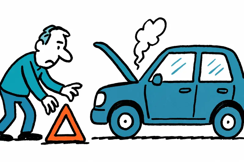
On a cool morning on the Ma-13, between Inca and Sa Pobla, a car breaks down. The driver stays belted in, places the yellow V16 on the roof and waits. The signal, intended as a safer alternative to the warning triangle, automatically sends the location to the traffic control center. What is useful for authorities and other road users is a precise hint for unknown persons: someone is currently vulnerable here.
Technically the system works as intended: the lamp flashes, a GPS point is sent to the central platform, and information is forwarded to navigation services and traffic apps. In practice, however, an immediate side effect became apparent: maps that visualize active warnings made individual vehicles publicly visible in real time. On an island where country roads and side streets are dark at night, this is not a minor problem.
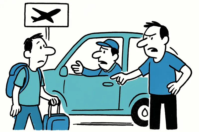
Critical analysis: automatic transmission of a precise GPS point has two sides. It is helpful for rescue and traffic flow. For the safety of individual people it creates an easily exploitable situational picture: remote location, duration of the warning, driving direction — all of this allows inferences that attackers can use. Not only for theft or assault, but also for so-called pirate towing services that deliberately move in to remove cars unofficially.
What is missing in the public debate so far are three points: first, the combination with other freely available data sources. An open live feed can be correlated with street cameras, social networks or viewed route profiles. Second, the question of how long position IDs remain visible on the platform and whether temporal delays can be activated by default. Third, liability: who is liable if an attack results from the published position — the light manufacturer, the platform operator or the authority?
An everyday observation from the island: at the petrol station on Passeig Mallorca a tow truck driver recently said he had received several unusual requests for remote "breakdown locations" since the beginning of the year. Residents on the PM-15 report that strange cars suddenly appear at night and turn into country lanes. Such scenes feel like opportunistic exploitation, not assistance.
Concrete, quickly practicable solution approaches:
1) Access restriction: live locations should only be transmitted to authorized emergency services, police and certified roadside assistance. A public map should be converted to an aggregated warning service without showing individual points.
2) Delay technology: by default, position transmission should be delayed by several minutes. In emergencies the driver can request immediate transmission, which is then activated after verification.
3) Authentication of service providers: towing companies and workshops must present digital certification in order to receive location data. Non-certified requests should be blocked.
4) Transparency and data protection: users must be clearly informed which data are sent, how long they are stored and to whom they are disclosed. A simple opt-out option for private users would be desirable, provided they are informed about alternatives.
5) Technical review of interfaces: open APIs must not deliver exact real-time data without authentication. Security researchers should have access to test systems so that vulnerabilities can be closed before production operation.
Legally, the traffic authority is responsible for managing the balancing act between traffic safety and personal protection; what drivers in Mallorca must know should inform the regulatory response.
Consider this: the V16 does not replace common sense. On Mallorca that practically means stopping in busier locations if possible, leaving lights on, locking doors and at night on the Ma-13 preferring to call roadside assistance before activating the lamp — if the situation allows it.
Conclusion: The idea behind the V16 is sensible. Field implementation shows, however, that raw real-time visibility can be risky for all involved. Without technical improvements and clear rules on data access, the lamp risks turning from a protective measure into a danger. On an island where some roads are quiet at night, policymakers must act quickly so the warning light protects lives instead of making people targets.
Frequently asked questions
What is the V16 warning light in Mallorca and why is it being introduced?
Can the V16 warning light make broken-down cars easier to target in Mallorca?
What should I do if my car breaks down on a Mallorca road at night?
Does the V16 warning light send your exact location in Mallorca?
Where on Mallorca could the V16 be most risky to use?
Are tow trucks and roadside services in Mallorca supposed to receive V16 location data?
What are the main data protection concerns around the V16 in Mallorca?
Will drivers in Mallorca still need a warning triangle with the V16?
Similar News

Game, Set, Applause: Glamorous Opening of the Mallorca Championships 2026
A summery opening of the Mallorca Championships 2026 at the Mallorca Country Club: celebrities, live music and a new sta...
Little Brunch at Playa de Palma: Why the Launch Is Slow — A Reality Check
Marco and Tamara Gülpen recently opened "Little Brunch" on the ground floor of their hostal at Playa de Palma. The openi...

"My Favorite Island": Emily Ratajkowski Back on Mallorca
U.S. model Emily Ratajkowski is once again spending time on the island: Cala Deià, a dinner by the sea and a stay in the...
Directly from the airport to Son Banya: When a transfer becomes a trip to the drug village
Shortly after landing, several German holidaymakers were picked up at the airport by a driver and taken to Son Banya — t...
Blockade on the Ma-10: Why a Flat-Tire Bus Paralyzes the Tramuntana
Between Deià and Sóller a coach came to a standstill on the Ma-10 on Thursday midday. A tyre blowout, two buses on the n...
More to explore
Discover more interesting content

Boat Tour with BBQ along Es Trenc Beach

Private transfer from Mallorca Airport (PMI) to Pollensa
