Aerial Images App: Mallorca’s Transformation from 1968 to Today at a Glance
Aerial Images App: Mallorca’s Transformation from 1968 to Today at a Glance
The Consell de Mallorca has launched an interactive map viewer that combines historical and current aerial photographs. Free, mobile-friendly and equipped with measurement tools, the app gives residents, planners and schools fresh insights into landscape and urban change.
Aerial Images App: Mallorca’s Transformation from 1968 to Today at a Glance
Consell’s free map viewer makes changes visible and invites exploration
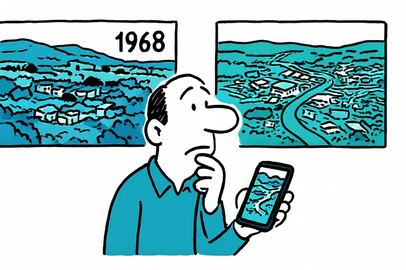
On the Passeig Marítim you can hear the engines of the fishing boats in the morning, on market day crows wheel above the Plaça Major and somewhere in the mountains goats’ hooves click – beneath it all lies a landscape that has changed markedly over recent decades. Those who want to know how much can now swipe instead of guessing: the Consell de Mallorca has published a new online map viewer that places historical aerial photos from the 1960s alongside current images.
The application is freely accessible, works on smartphones as well as on desktop computers and requires no registration. Users can compare two map years side by side, measure areas and distances, or save views as a PDF. That turns old photos into a tool rather than an archive image: farmers, municipal councillors, school classes or walkers on the Camí de sa Porrassa gain numbers instead of impressions.
For many Mallorcans the questions become very concrete: exactly where has development moved closer to the coast in the last 40 years? This trend is examined in When the Surroundings Overtake Palma: Opportunities, Risks and the Quiet Revolution on the Island.
In towns such as Alcúdia, Cala Millor or in suburbs of Palma, changes to harbours, road layouts and stretches of beach can be traced, a pattern mirrored by reports such as Mallorca's new residential axis: Villages grow, Palma keeps moving. The images also open a window onto memories: the older generation recognises terraces, cisterns or paths that are now barely visible.
Designed with practicality in mind, the measurement functions help beyond mere curiosity. Municipalities can carry out initial checks for planning, conservation groups can see the extent of built areas or vegetation loss, and schools can use the tool for geography projects. A PDF export makes it easy to present findings at citizen meetings or council sessions – no printing, no paperwork, but a digital site plan in your pocket.
I tried the app on a rainy morning in a café at the Plaça de Cort. While chestnut leaves slapped against the window outside, I pulled the 1968 image next to today’s: a green belt on the then periphery, now built over. At the next table two pensioners discussed how there had once been more farmland here; the app laid their story out as a visual trace. Scenes like that show how a digital tool can rekindle conversations about the island.
What concrete opportunities arise from this? Here are a few ideas that can be implemented quickly: workshops in libraries and casas de cultura to teach people how to use the measurement tools; open mapping days where volunteers add historical local knowledge; lesson modules for secondary schools that link spatial planning and environmental protection; and simple guides for municipalities on how to present the maps in participatory processes.
The app is not a cure-all: in-depth planning still requires professional surveys and on-site checks. But it is a practical start – a window that shows how landscapes and places have grown together or fallen apart. For an island shaped by tourism, agriculture and housing issues, it’s more than a toy for nostalgics: it’s a tool for informed discussion.
Those using the new map view should not only compare but also document: photograph the views, talk to neighbours about old paths, bring results to the ajuntament. The Consell’s images can thus become a resource for preserving local memory, a basis for discussions and teaching material. And next time you walk by the sea and the surf sounds louder, you might better understand why the bay looks different today than it once did.
Image credit: Consell de Mallorca
Frequently asked questions
How can I compare old and current aerial photos of Mallorca?
Is the Mallorca aerial map viewer free to use?
What can I do with the Mallorca aerial images app besides viewing photos?
When is the best time of year to use Mallorca’s map viewer for landscape comparisons?
Can the Mallorca aerial photos help with planning or local research?
What has changed in Palma’s coastline and suburbs over the years?
Can I find old aerial views of Alcúdia or Cala Millor in the Mallorca viewer?
How can schools use Mallorca’s historical aerial photos in class?
Similar News

Game, Set, Applause: Glamorous Opening of the Mallorca Championships 2026
A summery opening of the Mallorca Championships 2026 at the Mallorca Country Club: celebrities, live music and a new sta...
Little Brunch at Playa de Palma: Why the Launch Is Slow — A Reality Check
Marco and Tamara Gülpen recently opened "Little Brunch" on the ground floor of their hostal at Playa de Palma. The openi...

"My Favorite Island": Emily Ratajkowski Back on Mallorca
U.S. model Emily Ratajkowski is once again spending time on the island: Cala Deià, a dinner by the sea and a stay in the...
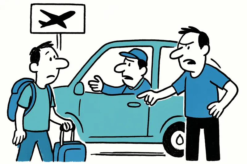
Directly from the airport to Son Banya: When a transfer becomes a trip to the drug village
Shortly after landing, several German holidaymakers were picked up at the airport by a driver and taken to Son Banya — t...
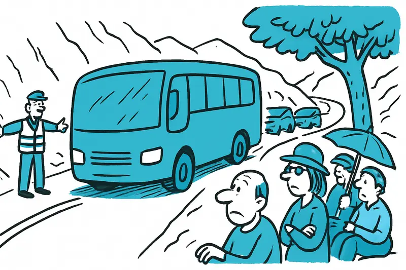
Blockade on the Ma-10: Why a Flat-Tire Bus Paralyzes the Tramuntana
Between Deià and Sóller a coach came to a standstill on the Ma-10 on Thursday midday. A tyre blowout, two buses on the n...
More to explore
Discover more interesting content

Boat Tour with BBQ along Es Trenc Beach

Private transfer from Mallorca Airport (PMI) to Pollensa
